Created: 2025-08-25 Mon 13:18
Motivation etc.
- So Jesuits in Kochi had ample opportunity to collect and translate Indian math and astronomy texts.
- But why were they interested in doing so?
Motivation: Navigational problem
- Europe then was very poor, all dreams of wealth (whether piracy or conquest) were overseas.
- Accurate navigation was needed to bring that wealth home.
- But Vasco and Columbus were zero in navigation as we saw.
- Europeans had 3 key navigational problems.
- Latitude, loxodromes, longitude at sea.
Latitude
- Vasco did not know how to determine latitude at sea,
- carried back Indian navigational instrument, kamāl
- to have it "graduated in inches" 😄
- (Can't be done: not a linear scale it uses a harmonic scale.)
- Kamāl tells latitude by the pole star.
- Since pole star=kau (Arabic-Malayalam) =teeth, and the string of the instrument is held between the teeth
- Vasco pompously and foolishly recorded "the "pilot" was telling the distance by his teeth".
- Despite stealing kamal, there still remained a problem of telling latitude in daytime:
- by measuring angular elevation of sun.
- That requires an accurate calendar which correctly determines the date of equinox,
- as explained in my Rajju Ganita geometry text for class 9.
- More precisely, to determine latitude of a place
- from observation of solar altitude at noon
- one needs knowledge of the declination.
- Hence, the "Noorie" tables.
- Q. What did Europeans do before the "Noorie tables"?
- A. After stealing the kamal, they could determine latitude but only in the Northern hemisphere (well above the south Africa cape)
- and only at night.
- A. They had no clear way to determine latitude at sea in daytime or in the southern hemisphere.
- My 9th std. text on geometry explains how to determine the altitude of the sun at noon by observing its shadow.
- provided one can calculate the arctangent.
- Or by directly looking at the sun
- to measure the angular elevation the way the kamal is used to measure the angular elevation of the pole star.
- (But you damage your eyes.)
- All ancient civilizations (except backward West) knew the date of equinox.
- The Maya demonstrated it most beautifully in the Chichen Itza pyramid.
- Indian and Egyptians knew about it.
- It is only the West which constantly boasted of supremacy
- which had an inferior Roman-Christian religious calendar with the wrong date of equinox (hence Easter).
- Hence, Christian priests were interested to steal calendrical knowledge
- for the Gregorian calendar reform of Christian calendar in 1582.
- They refused to acknowledge Indian sources because they always condemned knowledge from non-Christian (="heretical") sources
- and that too to correct their religious (AD-BC) calendar used to determine the date of Easter.
- (Easter, or the miraculous resurrection of Jesus after death on the cross, not Christmas, or his birth, was the main Christian festival until 2-3 centuries ago.)
Loxodromes
- Europeans navigated by plane charts, i.e., they tried to represent the spherical earth on a plane.
- They tried to travel in a fixed direction
- such as that set by a fixed direction of the compass needle
- or a straight line joining two distant stars (called a rhumb line).
- On their understanding of geometry (quadrivium) they expected this will result in straight line motion.
- This is a false expectation.
- On the curved surface of the earth
- motion in a fixed direction results in a curved line
- called loxodrome (loxos=curve, dromos = line).
Fundamental theorem of calculus a century before calculus!
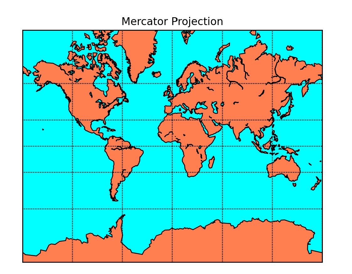
Mercator projection
- The projection maps the sphere to a plane chart in such a way that straight line course
- results in a straight line on the chart (loxodromes are straight lines).
- The Mercator projection does that. (This is nothing but the usual "map of the world".
- It is a conformal projection, i.e., angles are preserved so a course can be set by a fixed direction of the compass needle.
- 16th century navigational manuals were full of such tables.
- E.g., Simon Stevin's tables of 1590, derived from Aryabhata via Arabs (al Khwarizmi)
- How do we know?
- Since Stevin cites al Khwarizmi who literally quotes Aryabhata's value of π
- Aryabhata's verse is prolix since he adheres to the poetic metre in his Sanskrit verse.
- with laghu as 1 matra and guru as 2, he used the Arya metre of 4 lines of 12, 18, 12, 15 matras, respectively.
- Adherence to the metre (not needed for a prose depiction) shows al Khwarizmi did not quite understand it.
- Mercator's source unknown since he was arrested by the Inquisition
- and tortured for dabbling in heretical texts.
- A few years later (1607) Clavius published trigonometric tables with precision of nine decimal places.
- Clavius as the Jesuit general in charge of the Gregorian calendar reform
- was the natural recipient of Indian math and astromomy texts stolen by Jesuits.
- His trigo tables very similar to those of "Kerala school" (even use Rsine).
- Therefore, the European navigational problem of determining longitude at sea persisted until 18th c.
- Many European governments offered large prizes for its solution,
- the last being the British longitude prize legislated by an act of British parliament 1711-12.
- Only half of it given away in 1762
- because the Board of Longitude was only half sure that the prize had been won!
- Why did the Europeans have such a big problem with navigation?
- For many reasons. First, because they were superstitious
- and the Bible said the earth is flat
- unlike Indians who always knew the earth is round
- hence its very Sanskrit name is भूगोल
- Āryabhaṭa said the earth is round like a kadamba flower
- Lalla explained that is inferred from the fact that far off trees cannot be seen.
- All Indian ganita texts contain estimates of the earth radius
- whose high accuracy was confirmed by al Beruni's estimate in Arabic miles
- (see my book on Indian calendar).
- Getting over Bible superstitions, Columbus, to get funds for his project of traveling West to go East,
- deliberately underestimated the size of the earth by 40%
- this led to navigational disasters
- and the Portuguese law banning the carrying of globes aboard ships.
- Further, the fact is that though Europeans stole trigonometric values
- they did not know how to use them to measure the radius of the earth.
- Today Internet is full of bunkum stories of Eratosthenes
- a Greek
who supposedly measured the size of the earth.
- Nobody gives an actual primary source? Why not? (Bcoz source from 19th c.)
- Picard's 17th c. measurement was preceded even by al Mamun's 9th c. measurement by 800 years as usual.
- However, important point is that this is all in retrospect:
- in prospect no navigator was willing to trust his life to Picard
- therefore European problem of determining longitude at sea persisted.
- Further, as we will see in next lecture
- Europeans were very backward in math
- even in elementary primary-school arithmetic
- until the end 19th c., and even into the 20th c. algebra school-text of Hall and Knight which I was forced to study.
Indian method of determining longitude
- Many methods.
- A simple method was this:
- If one knows (1) the latitudes of two towns,(2) the distance between them and (3) the radius of the earth,
- one can calculate the longitude difference in yojanas
- by solving the longitude triangle as described by Bhaskara 1 (Laghu Bhaskariya 1.32, p. 11)
- Of course, it still needed accurate trigonometric values to solve the triangle
- from course angle and distance travelled.
- Naturally, they grabbed knowledge from every available source.
- There is ample circumstantial evidence they did so.
- Aryabhata's recursive method = "Euler" method (will cover this in detail, later)
- Nilkantha's planetary model= Tychonic model (see my book on Indian calendar) (Tycho as Royal astronomer to the Holy Roman empire was a natural recipient of stolen Indian texts)
- Madhava's sine values = Clavius' trigonometric values (which were an interpolated version)
- Brahmagupta-Vateshvar="Stirling's" formula
Documentary evidence
- Primary sources [Ricci's letter. (Ricci was Clavius' favourite student and biographer.)
- He was naturally searching for Indian calendrical texts in Kochi
- since this was right before the Gregorian calendar reform of 1582
- authored by Clavius.
- But in those days of the Inquisition
- it was impossible for the padres to admit that the reform of the Christian RELIGIOUS calendar was based on superior HERETICAL knowledge.
- (Note it was the Christian religious calendar,
- officially adopted at the first Nicene council to fix the date of Easter
- NOT the Julian calendar)
- which did not have any AD/BC as its starting point
- which starting point was fixed in the 6th c.
- in relation to the date of Easter.
- As usual the chief padre, the pope lied about the 1582 calendar reform telling the story that it was
- based on the "Alfonsine tables" from centuries ago
- and due to one Alyosisus Lilius a shadowy figure trained as a physician (not astronomer)
- But the story "established" that the knowledge had a valid Christian lineage.
- Why, then, was Ricci searching for knowledge of the calendar among heretics?😄